Earthquake Early Warnings.

Starting March 11, 2021, ShakeAlert®-powered earthquake early warning alerts will be available for delivery directly to wireless devices in Oregon.
In May 2021, Washington state will follow suit and complete the ShakeAlert public alerting rollout across the entire West Coast. California enabled ShakeAlert-powered alerts in October 2019.
As massive slabs of Earth squish into and grind past each other off the coast of the Pacific Northwest, many people may wonder when they will feel ensuing earthquakes.
Although the U.S. Geological Survey cannot predict where and when future earthquakes will occur, the bureau, along with a team of organizations, helped create a system that can provide vital seconds of warning that an earthquake is happening and shaking is imminent.
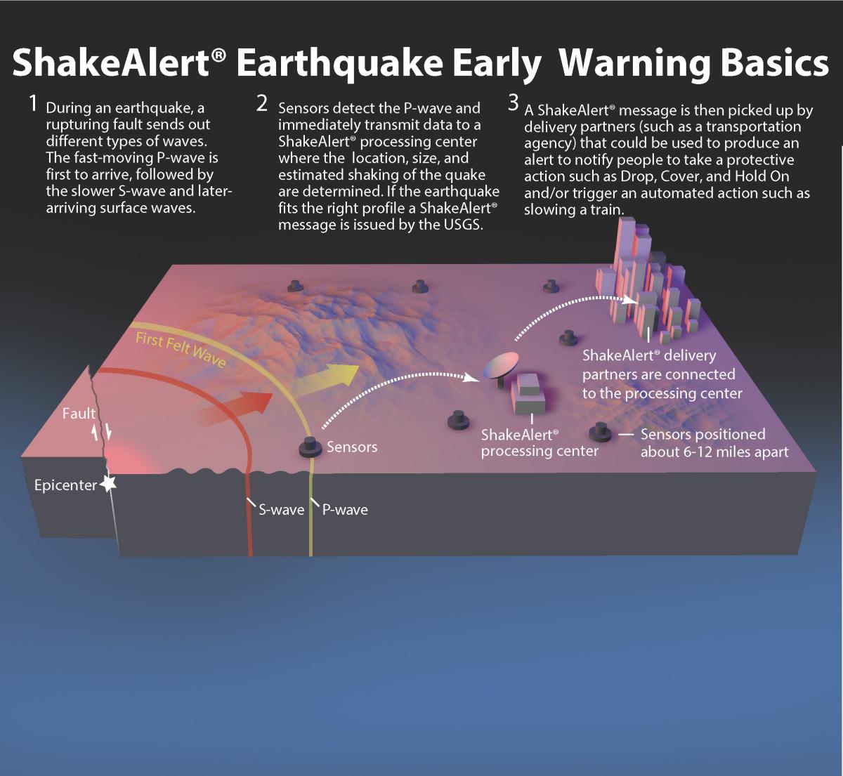
The ShakeAlert® Earthquake Early Warning system is a network of sensors that collects and shares real-time information about the magnitude, location and expected shaking from earthquakes on the West Coast to distribution partners who then deliver alerts via cell phones and the internet. Partners can also initiate automatic protective actions such as stopping trains to prevent derailments and closing water valves to protect infrastructure.
ShakeAlert can save lives and reduce injuries by giving people time to take protective actions, such as moving away from hazardous areas and making sure to drop, cover and hold on. ShakeAlert complements existing products from the Advanced National Seismic System that contribute to earthquake risk reduction.
For the first time, ShakeAlert-powered alerts will be delivered directly to wireless devices in Oregon starting on March 11, 2021. Oregon will be the second state to ”go live,” following California on October 17, 2019. Washington state will join Oregon and California in May 2021, which will complete the wireless alert delivery rollout across the entire continental West Coast.
For more than two years, a growing number of ShakeAlert technical partners in all three states have been using the ShakeAlert system for triggering automated actions to support public safety. Although ShakeAlert is operational in all three states, the USGS and its university and state partners are working to finish building the seismic network to support prompt earthquake detection. The network is now 70% complete for the West Coast, with 1,132 out of 1,675 seismic stations installed as of Jan. 31, 2021.
“The rollout of public alerting for ShakeAlert in the Pacific Northwest is a major milestone in the evolution of this critical system and has the potential to provide users with life-saving warnings seconds before they experience damaging shaking in future earthquakes,” Gavin Hayes, USGS senior science advisor for earthquake and geologic hazards, said. “This represents a major achievement for the USGS, the ANSS and for our state and regional partners.”
ShakeAlert-powered alert delivery in Oregon
Leading up to March 11, Oregon, in collaboration with USGS and other partners, will use various methods to announce the availability of alerts powered by the ShakeAlert Earthquake Early Warning system to be delivered to wireless devices. On March 11, ShakeAlert will be activated to deliver alerts directly to wireless devices in Oregon when earthquakes strike.
The delivery date coincides with the 10th anniversary of the magnitude-9.1 Great Tohoku earthquake in Japan, which took about 20,000 peoples’ lives. This quake was the strongest in Japan’s history and struck below the North Pacific Ocean, 81 miles (130 km) east of Sendai, the largest city in the Tohoku region. The quake caused a tsunami that produced waves up to 132 feet (40 m) high and caused the meltdown of three nuclear reactors at the Fukushima Daiichi Nuclear Power Plant.
After traveling across the Pacific, the tsunami rose to more than 26 feet (5 m) in Hawaii and more than 6.5 feet (2 m) in California and Oregon, causing debris to wash up on the Oregon coastline. A task force made up of state and federal agencies, along with non-governmental organizations, worked together for three years to coordinate nearly 900 clean-up events during which an estimated 40,000 volunteers picked up more than 446,000 pounds of debris on the Oregon coast.
Alert delivery using the WEA system will go live on March 11, with a WEA demonstration for educational purposes planned for July 2021 to allow time for Oregon, USGS and partners to broadly promote the system and effectively train the public on how to opt into the test and participate in a statewide alert experiment.
“Oregon is one of the most earthquake-prone areas in the continental United States, and over the years, we have had many earthquakes – large and small,” said Althea Rizzo, geologic hazards program coordinator for Oregon’s Office of Emergency Management. “Warning resources such as ShakeAlert can help to mitigate loss of lives, severe injury and devastating damage to infrastructure.
Earthquakes in the Pacific Northwest
Japan and the Pacific Northwest have almost mirror-image tectonic settings. Both are susceptible to quakes as one tectonic plate slides under another in a subduction zone.
The Pacific Northwest is susceptible to three main types of earthquakes as its underlying tectonic plates build up stress on faults: deep intraslab tremors that occur within a tectonic plate, shallow crustal quakes, and large megathrust earthquakes on the Cascadia Subduction Zone. The area can also experience episodic tremor and slip events, which can release energy equivalent to at least a M7 earthquake.
As the Juan de Fuca Plate spreads away from the Pacific Plate and plunges beneath the North American Plate, it’s strained as it’s bent and pulled by gravity into the Earth’s mantle. When the strain builds to a breaking point, earthquakes as deep as 25 to 43 miles (40 to 70 km) can occur within the Juan de Fuca Plate roughly every few decades; these quakes tend to happen beneath western Washington state.
There have been three deep intraslab quakes with magnitudes greater than M6.5 to hit the region since 1949: the M6.8 Nisqually quake on February 28, 2001, the M6.5 Puget Sound quake in 1965 and the M7.1 Olympia quake in 1949.
Shallow crustal earthquakes tend to occur less frequently than deeper intraslab quakes in the Pacific Northwest, but when they do happen they can be more damaging because of their shallow depths and proximity to densely populated cities. Some quakes are so shallow that they can break or deform the ground surface while others are up to 22 miles (35 km) deep and may not be connected to faults that we see at the surface.
The M6.8 to 7.5 Entiat earthquake in 1872 in central Washington and the approximately M7.5 Seattle Fault earthquake 900-930 A.D. are two examples of crustal earthquakes in the Pacific Northwest.
Lastly, the Cascadia Subduction Zone is a 600-mile (1,000 km) long megathrust fault with a history of large M8 to M9 earthquakes. It stretches from Northern Vancouver Island to Cape Mendocino, California, and separates the Juan de Fuca and North American plates.
Subduction zone earthquakes are the largest earthquakes in the world and reach magnitudes greater than 8.5. The last known megathrust earthquake in the Pacific Northwest was in January 1700 and was estimated to be M9. Looking at geological evidence, scientists estimate that these great earthquakes have occurred at least seven times in the last 3,500 years, which make them likely to happen on average every 400 to 600 years.
Earthquake early warning for the Pacific Northwest
In 2012, the Pacific Northwest Seismic Network, which is an Advanced National Seismic System regional network operated by the USGS, the University of Washington and the University of Oregon, joined the earthquake early warning efforts that began in California in 2006.
Incorporation of the PNSN into ShakeAlert extended the USGS ShakeAlert Earthquake Early Warning System across the entire U.S. mainland Pacific Coast, which grew to include support from the Gordon and Betty Moore Foundation, the City of Los Angeles and the state governments of California, Oregon and Washington.
Residents in most locations throughout the Pacific Northwest, including Seattle, Portland, Tacoma, Newport (Oregon) and Eureka (California) should expect that most alerts they receive will be from nearby shallow crustal and intraslab earthquakes.
The vast majority of these alerts will be for earthquakes smaller than M7. In these scenarios, ShakeAlert users who will experience strong (or worse) shaking should expect warning times of less than 10 seconds after which it becomes difficult to take protective actions because of the intense shaking.
In these quakes, there will be a region near the epicenter where shaking arrives before the alert. People should take protective actions as soon as they feel shaking whether they have received an alert yet or not.


